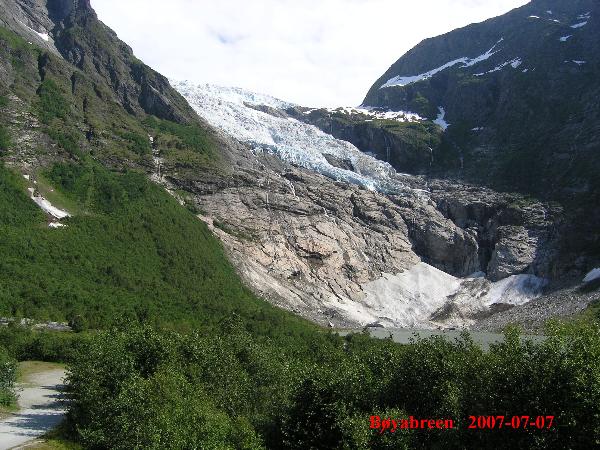
Glaciers can be defined as a large mass of snow, ice, and firn. With an area of approximately 500 square kilometres, the Jostedalsbreen is the largest glacier in Norway and in continental Europe. The central plateau is at 1600m to 1900m above sea level, but several outlets flow down into the surrounding valleys, for example Briksdalsbreen, Melkevollbreen, Brenndalsbreen, Bøyabreen, Nigardsbreen and so on.
Jostedalsbreen is no relic of the last ice age. It disappeared completely from 7000 B.C. until 4000 B.C. and then started to rebuild and grow again. Until today, the glacier and its outlets are continuously changing. The idea of this earthcache is to monitor the changing of the glacier outlet Bøyabreen over the years by setting up an image gallery, where the photos where all taken from a given reference point at Bøyabreen.
Bøyabreen can be reached by route 5. Travelling south the glacier will be on your left side directly after you leave the Fjærland tunnel.
To take credit for this cache, you have to
- upload a picture of Bøyabreen taken from the coordinates N 61 29.064 E 006 45.286 with the date you took it upon it but no people in the foreground (see reference photo above), upload a second picture which shows you or your GPSr at Bøyabreen (position is up to you; re-allowed by GC since June 2019) and
- e-mail me the answers to the following questions (info boards at N 61 28.863 E 006 44.706) in German or English before logging this as a found:
- How many meters does the ice of Bøyabreen move towards the glacier front per day?
- When did Bøyabreen split into upper and lower portions?
- What "made" the lower part?
- Which effect would a drop in summer temperature of 0,5°C (1°F) have?
- When did Bøyabreen have its maximum extent and how many meters did the glacier outlet reach further down the valley?
Enjoy your visit!
Logs without the required e-mail or photo will be deleted without comment. Due to "administration" of the log-permissions it is nessecary that every team send an e-mail by itsself even if you were there together. You don't have to wait for log-permission, please log directly after sending your mail, we will contact you if there is something wrong.
For further pictures see here.