Besøk steg 1,2,3 og 4 på veipunkta og samle dei rette tala A, B, C og D.
Steg 1 (Veipunkt A1): Kor mange vindauger er det på veggen?
5 vindauger A=2
8 vindauger A=9
3 vindauger A=7
Steg 2 (Veipunkt B2): Kor mange bilete er det på turtavla?
7 bilete B=5
5 bilete B=7
3 bilete B=1
Turtavla er borte. B=1
Steg 3 (Veipunkt C3): Kor mange skilt ser du?
1 skilt C=9
3 skilt C=7
2 skilt C=0
Steg 4 (Veipunkt D4): Kva står på skiltet?
"Kyrkjevegen" D=2
"Sverrestigen" D=6
"Postvegen" D=1
Set inn dei rette tala i staden for bokstavane:
N61 03.CCA E007 48.DCB og finn cachen.
Du kan sjekka koordinatane dine her: GeoChecker.com.
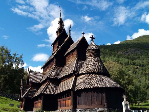
Borgund stavkyrkje
Lærdal og Borgund har ein sentral plass i norsk veghistorie. Her har hovudvegen mellom aust og vest, over Filefjell, gått i all tid. Då Borgund stavkyrkje vart bygd her i 1180-åra, var ferdslevegen alt urgamal.
I Vindhella, like bak stavkyrkja, ligg eitt av dei finaste og mest imponerande veganlegga som finst i landet. Å byggje veg her var ekstra vanskeleg, for skaret er både bratt og trongt, og vegen måtte leggjast på høge murar. Den første køyrbare vegen for hest og kjerre kom med Den Bergenske Kongeveg i 1790-åra. Men det var i 1840-åra at strekninga gjennom Vindhella fekk si karakteristiske form, med dei kjende hårnålssvingane som ein kan oppleve her i dag.
Vindhella er ein del av den 10 mil lange vandreruta Kongevegen over Filefjell, som tek deg gjennom nokre av dei vakraste landskapa i Noreg. Frå tronge og dramatiske fjordlandskap inst i Sognefjorden, via høgfjellet på Filefjell, og ned i innlandsbygdene i Valdres. Ei reise mellom landsdelane - med den historiske Kongevegen som den raude tråden undervegs.
Frå Borgund stavkyrkje tek det omlag 10 minuttar å gå til toppen av Vindhellaskaret. Ein fin rundtur får du om du går ned Vindhellaskaret og tilbake via Sverrestigen, oppkalla etter kong Sverre som reiste forbi Vindhella i år 1177. Følg merkt veg!
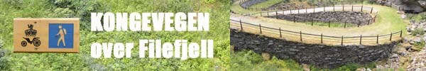 Då den Bergenske Kongeveg vart bygd på slutten av 1700-talet, fekk ein for fyrste gong køyreveg mellom Aust- og Vestlandet. I dag er den gamle Kongevegen eitt av dei finaste veghistoriske kulturminna vi har. Den 10 mil lange vandreruta Kongevegen over Filefjell tek deg gjennom nokre av dei vakraste landskapa i Noreg. Frå tronge og dramatiske fjordlandskap inst i Sognefjorden, via høgfjellet på Filefjell, og ned i innlandsbygdene i Valdres. Ei reise mellom landsdelane - med den historiske Kongevegen som den raude tråden undervegs. Der vegen er borte nyttar ein andre trasear, slik at det blir ein samanhengande turveg frå Lærdalsøyri til Vang. Syklistar har alternative ruter utanom dei mest sårbare delane av Kongevegen.
 Visit step 1,2,3 and 4 on waypoints and collect the correct numbers A, B, C and D.
Step 1 ( Waypoint A1) : How many windows is it on the wall ?
5 windows A=2
8 windows A=9
3 windows A=7
Step 2 ( Waypoint B2) : How many images on the infoboard ?
7 images B=5
5 images B=7
3 images B=1
The infoboard is missing. B=1
Step 3 ( Waypoint C3 ) How many signs do you see?
1 Sign C=9
3 Signs C=7
2 Signs C=0
Step 4 ( Waypoint D4) : What is on the sign ?
"Kyrkjevegen" D=2
"Sverrestigen" D=6
"Postvegen" D=1
Set the correct numbers instead of letters: N61 03.CCA E007 48.DCB and find the cache.
You can check your coords here: GeoChecker.com.
Borgund stave church
Lærdal and Borgund have been central in Norwegian road history, and have always formed part of the main route between east and west, across Filefjell. When Borgund Stave Church was built in the 1180s, this was already an ancient travel route.
In Vindhella, just behind the church, you will find one of the county’s most beautiful and impressive stretches of road. Its construction was particularly challenging as the pass was steep and narrow, and the road had to be built on high foundation walls. The first road suitable for horse and cart was Den Bergenske Kongeveg, built in the 1790s. It was not until the 1840s that the stretch through Vindhella was given its current characteristic shape with the renowned hairpin bends.
Vindhella forms part to the 100 km Kongevegen across Filefjell walk, leading through some of Norway's most spectacular scenery. From the narrow, dramatic fjord landscape innermost in the Sognefjord, via the high mountains at Filefjell, and down to the inland villages in Valdres. A journey from one part of the country to another – linked together by the historic Kongevegen.
From Borgund Stave Church, there is an approx. 10-minute walk to the top of Vindhellaskaret. For an excellent round-trip, walk down Vindhellaskaret and return via Sverrestigen – a trail named after King Sverre who travelled through Vindhella in 1177. Follow the way-marked route!
Bergenske Kongeveg, built at the end of the 1700s, was the first proper road between eastern and western Norway. Today, the old Kongevegen is one of our most beautiful cultural heritage routes. The 100 km Kongevegen across Filefjell walk leads through some of Norway's most spectacular scenery. From the narrow, dramatic fjord landscape innermost in the Sognefjord, via the high mountains at Filefjell, and down to the inland villages in Valdres. A journey from one part of the country to another – linked together by the historic Kongevegen.
Kilde/Source: Statens vegvesen