Purcell Trench EarthCache
-
Difficulty:
-

-
Terrain:
-
Size:  (not chosen)
Please note Use of geocaching.com services is subject to the terms and conditions
in our disclaimer.
This earthcache is located off of Idaho HWY 53 just east of the Idaho/Washington state line and is an established Idaho Department of Transportation Geological Site.
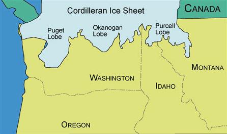
During the Pinedale Glaciation, which lasted between 20,000 to 80,000 years ago, Canada and the northern United States were glaciated by two large continental ice sheets. The Cordilleran Ice Sheet, the smaller sheet, covered southwestern Canada and the northern areas of Washington, Idaho, and Montana. It was approximately 1150 meters thick and contained three main lobes. The western lobe was called the Puget Lobe and scoured out Puget Sound in northwestern Washington. The central lobe was called the Okanogan Lobe. It blocked the Columbia River at the location of the current Grand Coulee Dam, forming Glacial Lake Columbia. The Purcell Trench Lobe, the eastern lobe, dammed the Clark Fork River several times to form Glacial Lake Missoula.
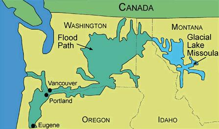
When the Purcell Trench snaked south from Canada, it scoured out the basin that now holds Lake Pend Oreille. From there, the appendage stretched southwestward, this far into Idaho. The ice left in the tracks of the extending arm eventually plugged the Clark Fork Valley and dammed the Clark Fork River near the place where it spilled into Lake Pend Oreille. This large ice dam blocked the Clark Fork River, allowing water to build up behind it, extending eastward some 200 miles into western Montana. Glacial Lake Missoula then formed behind this ice dam. This massive lake covered about 3,000 square miles. The lake was nearly 2,000 feet deep at the ice dam and 950 feet deep at Missoula, Montana. This is more water than Lake Erie and Lake Ontario combined.
Inevitably, the lake level reached the lip of the ice dam and began to overflow. The running water weakened and cut deeply into the dam until it collapsed, releasing the contents of glacial Lake Missoula. Water from Lake Missoula burst through the base of the dam, at a rate of ten times the combined flow of all the rivers in the world! Calculated flood speeds reached almost 65 miles per hour. At this rate, the lake would have drained in only a couple of days. The water poured out of the mouth of the Clark Fork Valley, swept through Lake Pend Oreille, and spread across eastern Washington.
Rocks and boulders transported to this area by the Purcell Lobe also backed up Lake Coeur d'Alene. The mountains which you can see from here today look drastically different than they did when the ice came through this area. They now tower thousands of feet. However; when the Purcell Trench Lobe reached this far into Idaho these mountains were almost entirely covered by the massive sheets of ice.
To claim this earthcache you need to answer the following questions by emailing your answers to Martin 5. Although not required we also request you PLEASE POST A PICTURE yourself with your GPS using the front of the sign as your back ground.
1) Describe what the area to the south looks like today?
2) Continuing to look to the south, how tall would you estimate the mountain range is today at it's highest peak?
3) On the back of the sign you will find two locations with coordinates. Program the two sets of coordinates into your GPS and record how far away each location is from the sign. Email what the locations listed are and the distances you come up with.
4) To help give you an idea of just how massive the Purcell Trench really was multiple the two distances you came up with above with each other. The number you come up with is just a very low estimate of how many square miles it could have been. Email your answer to this question. Now that is a lot of ice!!
Have fun!!!
Martin 5
Platinum Earthcache Master


| If you are a Geocacher in eastern Washington or northern Idaho, please join the Inland Empire Chapter of the Washington State Geocaching Association. This is a great way to get the most out of Geocaching in our region. Simply go to the WSGA Web Page for details! |
 |
Congratulations to KdOg52 for being first to complete the logging requirments for this earthcache and on 10-10-10 International Earthcache Day!!
Additional Hints
(No hints available.)