EarthCache Goal: Learn how to
identify soil and why soil is important to everyone.
Background:
Soil identification (don’t call it ‘dirt’ around
a soil scientist!) is an important method for pedologists and
gardeners alike. Pedology is the study of soils, particularly
pedogenesis (how it forms), soil morphology (composition,
structure, organization), and classification.
It is important to study soil because it serves as a zone of
interactions between climate, soil life (plants and animals),
mineral material of the original weathered rock, and its relation
to the landscape. It also:
• Provides a medium to grow produce
• Produces and stores gases like CO2
• Stores heat and water
• Provides a home for plants, animals, and
microorganisms
• Filters water and wastes
• Provides a material for construction, medicine, art,
etc.
• Decomposes waste
• Provides record of geologic, climatic, biological, and human
history
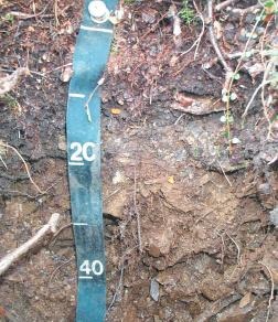
Figure 1: Soil horizon studied by the 1997-2002 soil survey
researchers in Denali
Because it covers only 10-11% of the earth’s surface, soil
should be studied to learn how it should be used and conserved
properly. A massive soil survey was conducted in Denali from 1997
to 2002 during the months of July, August, and September.
Researchers dug over 2,000 soil pits, each one meter deep. Their
goal was to describe and map all the soils of Denali by covering
one sixth of the Park each year – about 405,000 hectares, or
4050 square kilometers. For future soil studies, researchers now
have a baseline dataset of soil and environment types for the
entire Park. Because this study required researchers to visit
nearly every corner of the park, they created a comprehensive
ecological database that includes plant species. Creating this
baseline dataset is vital for monitoring ecological
changes.
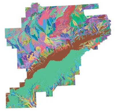
Figure 2: The soil map produced by the 1997-2002 field research.
With the right technique, you can almost identify soils in the
field as accurately as in a laboratory. Remember that sand is
gritty, silt is smooth, and clay is plastic and sticky. Sand grains
are large enough to be seen with the unaided eye and can be felt
individually between fingers. Silt cannot be seen with unaided eye
or felt between fingers. Clay can only be seen with an electron
microscope.
Try the following technique suggested by McDaniel et al. (1997) in
Maley (2009):
1. Fill the palm of your hand with dry soil.
2. Moisten the soil enough that it sticks together and can be
worked with your fingers. Do not saturate it. If it sticks to your
fingers, it’s too wet.
3. Knead the soil between your thumb and fingers. Take out the
pebbles and crush the soil clumps.
4. Estimate the sand content by the amount of textural grittiness
you feel.
5. Estimate the clay content by pushing the sample between your
thumb and index finger to form a ribbon.
a. Less than 27 percent: the ribbon is less than 1 inch (2.5 cm)
long.
b. 27-50 percent: the ribbon is 1-2.5 inches (2.5-6 cm) long.
c. More than 40 percent: the ribbon is 2.5 inches (6 cm)
long.
6. Combine sand and clay percentages and subtract from 100% to get
silt content.
How to use the ternary
diagram:
Another way to think about this diagram is placing silt at the
right-hand corner, placing sand in the left-hand corner, and
placing clay in the top corner. Notice that for whatever particle
size is in the corner, the percentage is 100%. Percentages decrease
in each line moving away from that corner.
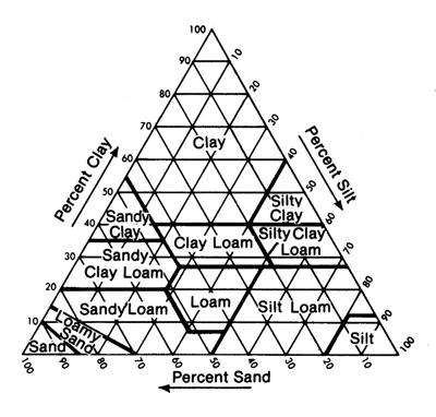
Figure 3: Blank ternary diagram of sand, silt, and clay. Image from
Long Island University.
1. Estimate the percentage of clay, silt, and sand in the soil. The
three percentage values must add to 100%.
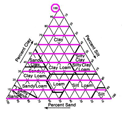
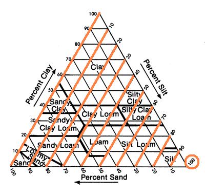
Figure 4: Percentage lines top to bottom: Clay, silt, and sand.
100% for each is circled.
2. On the right side of the diagram, find the percent of silt
you found (for example, 40%, orange line). Highlight the line that
radiates downward from that number to the left.
3. On the bottom side of the diagram, find the percent of sand you
found (for example, 30%, green line). Highlight the line that
radiates up and to the left.
4. On the left side of the diagram, find the percent of clay you
found (for example, 30%, pink line). Highlight the line that
radiates horizontally to the right.
5. Where all three lines meet is the category your soil fits into.
The example soil is clay loam (orange rhomb).
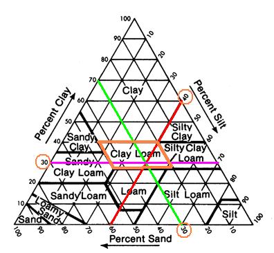
Figure 4: The example ternary diagram showing a 'clay loam'
classification
How to access this
EarthCache:
This cache is located along the Roadside Trail which can be
accessed by the Denali Visitor Center. Please only find this cache
from the trail instead of cutting in from the road (and return the
same way).
What you need for this
EarthCache:
Water for estimating sand and clay content. This is probably best
done on a non-rainy day.
Please remember to practice Leave No Trace ethics to preserve this
experience and environment for future visitors:
• Hiking off-trail is not required at this EarthCache.
• Collecting samples is not allowed in National
Parks.
To log this EarthCache: Email the answers to the following
questions to me (click my username up top, send message).
1. What percentage of sand, silt, and clay did you determine is in
the soil?
2. Based on the sand-silt-clay triangle, what type of soil is this?
Ignore all other particle sizes in the outcrop for now.
3. Describe some properties of the soil you have identified
(research out of field. The OSHA site ‘Field Method for
Identification of Soil Texture’ is a good place to
start).
Sources:
Clark, M.H., and Duffy, M.S., 2006. Soil survey of Denali National
Park and Preserve. National Cooperative Soil Survey.
Lambert, D. The Field Guide to Geology. 2007. New York: Checkmark
Books.
Maley, T.S., 2009. Field Geology Illustrated. Ann Arbor: Sheridan
Books.
Soil Survey Division Staff, 1993, Soil Survey Manual, United States
Department of Agriculture Handbook No. 13, p. 437.
Soil Survey Staff. 2004. Soil Survey of Denali National Park Area,
Alaska. U.S. Department of Agriculture, Natural Resources
Conservation Service and U.S. Department of the Interior, National
Park Service.
Why Do We Study Soil? . 2 June 2010.
This EarthCache was created by the
Geological Society of America summer 2010 GeoCorps intern at Denali
National Park and Preserve.