The Talus Slopes of Mt. Fairview EarthCache
The Talus Slopes of Mt. Fairview
-
Difficulty:
-

-
Terrain:
-

Size:  (other)
Please note Use of geocaching.com services is subject to the terms and conditions
in our disclaimer.
NOTE: Lake Louise can be avalanche prone in the winter. Please check with local authorities before venturing out onto the lake for guidance if you visit during the winter.
 When rock on the side of a mountain is exposed to snow and rain, the water from the elements gets into the small cracks in the rock and can freeze and then thaw. These repeated freeze thaw cycles can cause the rock to crack. The cracks expand and join, eventually causing pieces of rock to fall down the side of the sheer cliff forming a pile of rocks at the base of the mountain.
This "pile of rocks" is called a talus or scree pile. The talus collects at the base of the mountain and forms a characteristic triangular conic shape, with the point of the cone pointing to the place where the talus is funneled by the mountain's topography as it falls down the mountain.
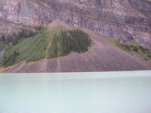
For this cache, I will walk you through the calculations to figure out how much rock falls down the mountain in an average year. The math is not difficult (nothing more complicated than multiplication and division) and I give you the formulas you will need to use for every step. You will need to estimate several items related to the formation of the large talus pile at the bottom of Mt. Fairview which lies to the east of Lake Louise. There are several origin points for the talus slopes which you can see, but for the purposes of this earthcache, concentrate only on the largest talus pile which originates the highest up on the side of the mountain.
1) While walking along the western lake shore trail along Lake Louise, you will need to measure the approximate width of the base of the talus pile. This can be done using your GPS and setting a waypoint when you think you are opposite the first point where talus from the highest pile would fall. Walk farther along the trail until you are opposite the point where it ends. Measure the distance back to the first waypoint and this will be an approximate width of the talus slope. If you don't have a GPS with this capability, you can estimate it using paces along the lakeshore or some other method. Please make the estimate in meters, which is the common unit for scientific measurements of length.
2) Knowing the width of the base of the talus slope, use your sense of proportion to estimate the height of the pile.
3) Use your estimate of the width and height of the talus pile to provide an estimate of the volume of the pile. The easiest method is to assume that the volume of material is half of a cone shape. The formula for the volume of a half-cone is:
Volume = Pi * Height * Base * Base / 24
4) Now that you know the approximate volume of the pile, the next step is to calculate the mass of the pile. Talus piles have a lot more air than solid rock, so this has to be taken into account. Measurements in the lab estimate that the porosity of the talus is about 33%, so to calculate the mass, use the following formula:
Mass = Volume * Density * (1 - Porosity)
The density of rock varies slightly by type, but typical sedimentary rocks average a density of about 2600 kg/m3. So the formula becomes:
Mass = Volume * (2600 kg/m3) * (1 - 0.33)
5) The final step in the calculation is to figure out how much rock falls down each year. As the talus slope has presumably been collecting at the base of the mountain since the end of the last ice age (about 10,000 years), estimate the mass of rock that falls from Mt. Fairview to this talus slope each year.
Send me your answers for steps 1-5 in an email and do not post them with your log. While not required, a picture of you with the talus slope in the background would be a nice addition to the log.
Congratulations to minordeity for FTF!
| I have earned GSA's highest level: |
 |
References:
http://en.wikipedia.org/wiki/Scree
"The modelling of particle systems with real shapes" By J.-P. Latham1 and A. Munjiza Phil. Trans. R. Soc. Lond. A (2004) 362, 1953–1972
http://www.enotes.com/earth-science/talus-pile-talus-slope
http://alliance.la.asu.edu/slides/stop02/2b/2b.html
http://en.wikipedia.org/wiki/Frost_weathering
This earthcache placed with the permission of Parks Canada
Additional Hints
(No hints available.)