Note: This is an Earthcache. Put simply, that means it is not a traditional cache, but its purpose is to help educate those who find it about some geologic aspect of the area they find themselves in. To log this cache, you will NOT be looking for a typical geocache container (in fact, there IS no container to find). Rather, to prove you were here and learned something you'll need to find the answers to the given questions (found at the end of this cache description), which you will then email me, the owner (this is the same process for ALL Earthcaches).
So go ahead and log your experience while here, submit photos, etc., but email your answers to me (not in your visit log) to get credit for "finding" this cache. If it seems too complicated, don't sweat it too much (as long as I can see that you made an honest effort to answer all of the questions, that is fine). Remember that the purpose of this is to learn something, and most importantly, to have fun! Also, feel free to email me with any questions you may have, I'd be happy to help.
Note: The cache description mentions that special tools are required; this cache has two options: a non-fee option (see waypoint on where to go), and the fee option (again, see the applicable waypoint). One will take you to an area nearby the fee area, without entering it, and the other will require you pay the fee. If you choose the fee option, the tool you will need is a simple magnet, needed to help answer one of the questions.
Special thanks goes out to Jay Cram, BLM Outdoor Recreation Lead at Little Sahara Recreation Area, who helped make this cache possible. As you do this earthcache, please respect the area and practice "Leave No Trace" ethics.
Introduction: The Little Sahara sand dunes, located in the northeastern part of the Sevier Desert in western Utah, lie within the northern half of one of Utah’s largest dune fields (about 220 square miles). This dune field contains both actively forming or migrating dunes and plant-stabilized dunes.
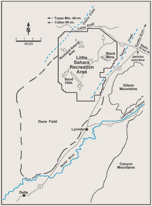
Administered by the Bureau of Land Management, Little Sahara Recreation Area is mostly devoted to off-road vehicle use, with as many as 300,000 thousand people recreating here annually. The Rockwell Natural Area, located in the northwest corner of Little Sahara (see map below), is a 14-square-mile section off limits to vehicles in order to preserve and shelter desert plants and animals.
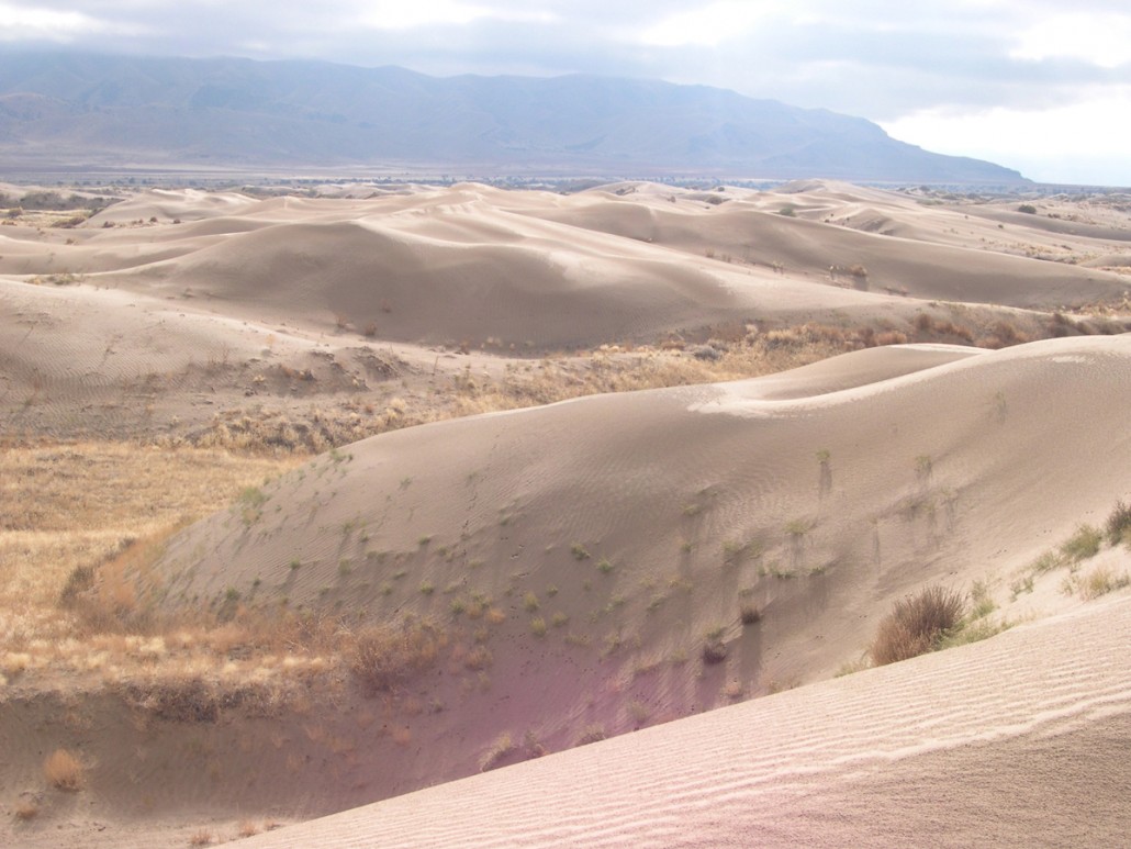
Above: Sand dunes on the east side of Little Sahara Recreation Area. Gilson Mountains in background.
While exploring the area, you may notice that the sand dunes, scattered junipers, and sagebrush flats provide habitat for a diverse array of plants and animals. Mule deer, antelope, the kit fox, 15 species of birds (including Great horned owls), the Desert whipsnake, and 8 other species of reptiles live here. You'll likely see stands of Utah juniper, sagebrush and grasses typical of the Great Basin dotting the landscape.
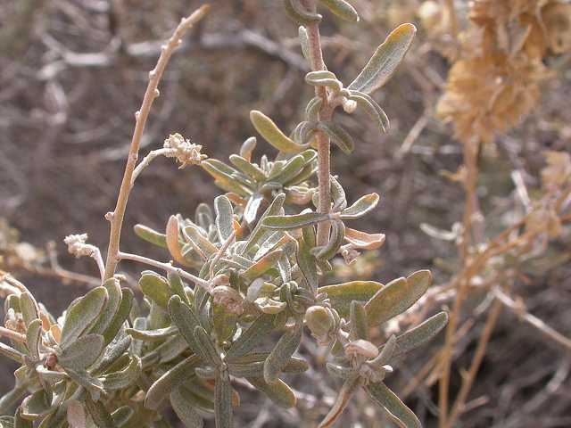
For example, Atriplex canescens variety gigantea, also known as giant four-winged saltbush, is a truly unique plant species found here. The dune fields of Little Sahara are the only place in the world where this particular variety of saltbush grows naturally. Special adaptations, such as rapid root growth, huge size, and the ability of stems to develop roots, enable this saltbush to survive in Little Sahara's harsh environment of shifting sand.
Above right: A photo of the rare atriplex canescens variety gigantea, aka giant four-winged saltbush.
Geologic Information and History: The Sevier Desert was inundated by waters of prehistoric Lake Bonneville from about 20,000 to 12,500 years ago. Lake Bonneville was a large freshwater lake that at its greatest extent covered most of Utah’s western valleys and small parts of Idaho and Nevada.
Two distinct shorelines were created while the lake occupied this area, the Bonneville (highest) and the Provo (named for Provo, UT, where the line can be easily seen as a bench on the nearby mountains) shorelines. Each formed when the level of the lake remained relatively constant for hundreds of years.
A large delta formed where the Sevier River, after leaving the nearby Leamington Canyon, entered Lake Bonneville while at the Provo level. This ancient delta extends from the area near the mouth of Leamington Canyon to just north of the town of Delta.
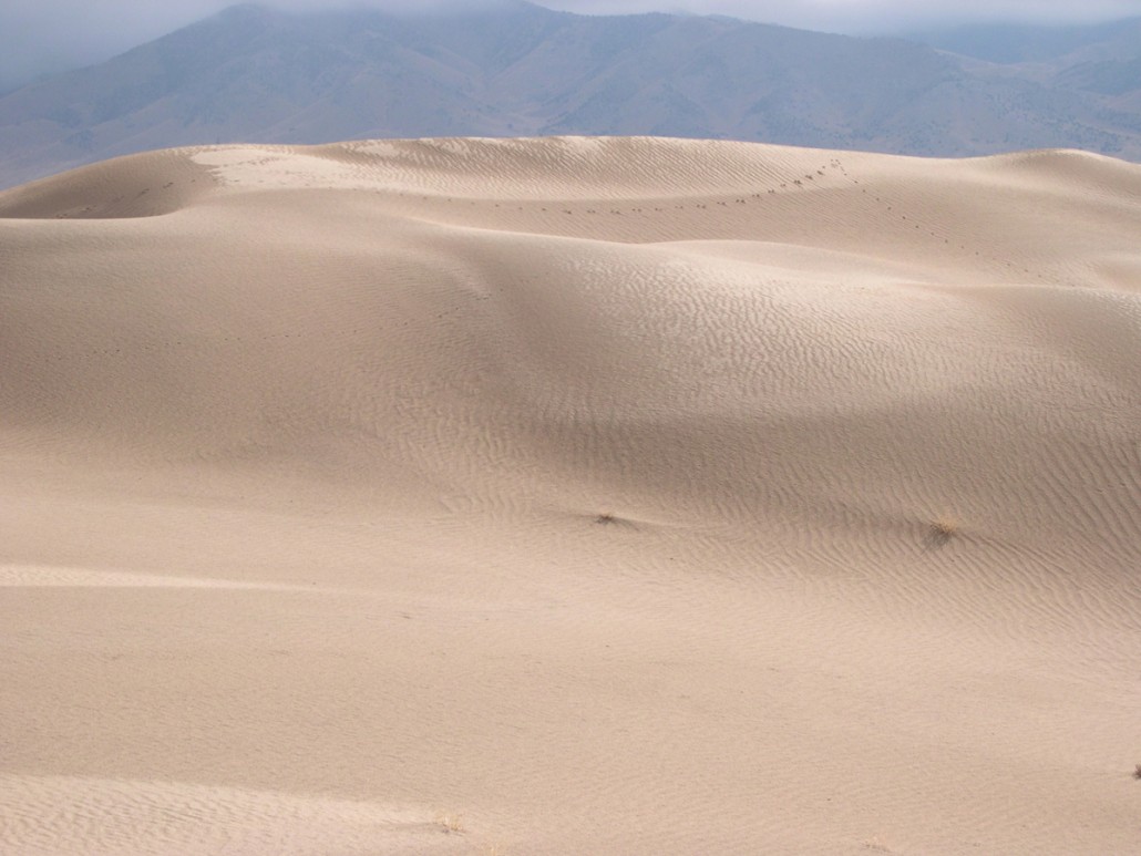
Below: Little Sahara sand dunes.
Changing Conditions:
After Lake Bonneville receded, winds dominantly from the southwest began to transport some of the exposed deltaic sand northeasterly. Sand Mountain, in the middle of the dune field, deflected the wind upward, causing it to slow and drop its load of sand. Sand particles, composed mostly of quartz, fell downwind among the sagebrush and juniper around Sand Mountain ultimately creating a 124-square-mile system of giant, free-moving, sand dunes., eventually creating the current dune field. Most of this dune field is still active, with dunes migrating usually between 5 to 9 feet per year (though in some years, 20+ feet of movement has been recorded).
Generally, the quantity of windblown sand in the dune field increases as you move farther northeast. A gradual rise in elevation to the northeast and bedrock barriers within the dune field cause the moving sand to slow or stall and accumulate.
The most prominent barrier is the Sand Hills (also known as Sand Mountain) located within the recreation area. The Sand Hills lie directly in the path of migrating dunes and are aligned at right angles to the prevailing wind direction. Sand travels around the ends of the hills or through passes to form dunes on the other side.
 Although the sand consists mostly of quartz grains, minor amounts of felspar, biotite, calcite, garnet, magnetite, and other minerals are also present. Interestingly, magnetite, an iron oxide, is the most magnetic naturally-occuring mineral on earth. The metallic magnetite probably eroded from volcanic rocks along the path of the Sevier River, coming from the nearby Gilson Mountains to the east.
How to get there: The Little Sahara Recreation Area is about 110 miles from Salt Lake City via Nephi. Travel on I-15 to Nephi. Take exit 225 and travel west 14.5 miles on State Route 132 to Juab County Route 1812 (“Sand Dunes” sign).
Turn right (northwest) onto Route 1812, travel about 14 miles, passing through Jericho Junction (intersection with U.S. Highway 6), until you reach the turnoff sign for Little Sahara Recreation Area. Turn left (southwest) to enter the area. There is a daily use fee ($18 as of 2014).
In summary, this is just one of Utah's many geologic wonders that continues to provide beauty and entertainment for thousands of people every year (over 300,000 visited here last year alone). I hope that in visiting this earthcache, you've learned something new. Thanks for visiting!
Source: http://geology.utah.gov/surveynotes/geosights/little_sahara.htm
In conclusion, remember: to log this cache, use the following info, your surroundings and head to answer the following questions. Email me the appropriate answers (don't post them in your log, or per Earthcache guidelines your post will have to be deleted), and most of all, have fun!
Option #1; fee area (I recommend White Sands campground fenced-off play area, where the cache is shown on the main map):
- According to the reading, how did all this sand get here? Based on that, give a short description of your best guess of the process that had to occur to bring this sand here, from the source rocks, all the way to the tiny grains of sand that you see now.
- Take your magnet, and try pouring a steady stream of sand over it; blow off any excess sand; do you notice anything left behind that is attracted to the magnet? If so, describe what you are seeing; what is it, most likely? And where did it likely come from?
- Take a handful of sand, and look at the different grains. Describe their size, how they look, feel, etc. Based on the reading, what is the sand made of?
- (Optional) Find some nearby dune(s) (or something else you see) that impresses you, and post a picture (with yourself if you wish).
Option #2; non-fee area (head to one of the Non-fee area waypoints, then answer the following questions):
- According to the reading, how did all this sand get here? Based on that, give a short description of your best guess of the process that had to occur to bring this sand here, from the source rocks, all the way to the tiny grains of sand that you see now.
- According to the reading above, is this an actively migrating dune field? Why / why not? Take a moment to observe the dune field and its surroundings; from what you can observe, do you reach the same conclusion? Why / why not?
- Take another look around you at the dune field. Based on your surroundings, what you've read and observed, etc., do you expect this dune field to (in the future) shrink, remain the same, or grow in size? Explain why.
- (Optional) Find some nearby dune(s) (or something else you see) that impresses you, and post a picture (with yourself if you wish).
This cache was created by an
