Note: I created this cache as part of the Original Utah Geotour, which ended in September 2019. Thanks for all those who made it fun!
Eureka History
In 1869 suddenly the word “Eureka” was gold on everyone’s lips. Large gold nuggets were found in the Tintic Mountains, and hundreds moved in to stake their claims. By 1870 the tent city was called Eureka. Sunshine Mine with its motherlode of rich ore produced millions of dollars in gold, silver, lead, and other metals. On the other side of the mountain, another large discovery was made. The extent of the motherlode was so large, it was named Mammoth , and a city grew there also. Several other mining communities sprang up nearby, such as Dividend, Knightsville, etc.
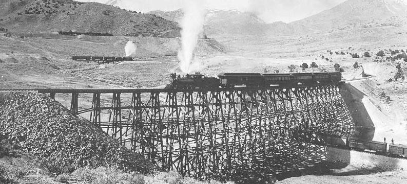
The famous 1892 "Double Loop" photograph by C. R. Savage, of the DRGW railroad nearby Eureka, UT.
Can you find the four different trains shown in the photo?
(Source: Utah State Historical Society)
Eureka was originally known as Ruby Hollow before it developed into a bustling mining town. Incorporated as a city in 1892, Eureka became the financial center for the area, known as the Tintic Mining District, a wealthy gold and silver mining area along the border of both Utah and Juab counties. The district was organized in 1869 and by 1899 became one of the top mineral producing areas in Utah. The Eureka Micropolitan Statistical Area housed many mines, including the "Big Four" mines—Bullion Beck and Champion, Centennial Eureka, Eureka Hill, and Gemini-and later the Chief Consolidated Mining Company.
Eureka's role as the central financial point for the district ensured its survival. It housed business establishments, including the second-ever JC Penney store (then called the Golden Rule Store), financial institutions, local and county governmental buildings including Eureka City Hall (1899) and the Juab County Courthouse (1892), various churches, and the meeting places for numerous labor, social, and fraternal organizations. Mining entrepreneurs such as John Q. Packard, John Beck, Jesse Knight, and Walter Fitch Sr. were important figures in Eureka and Tintic history. In 1979, Eureka was placed in the National Register of Historic Places as part of the Tintic Mining District Multiple Resource Area, recognizing the importance of remaining buildings and sites.
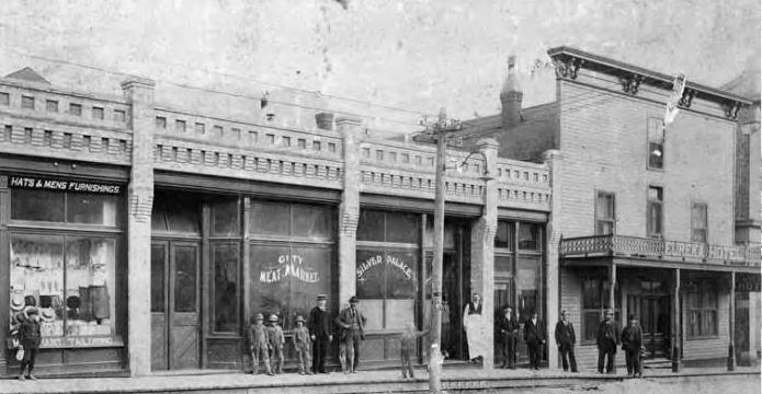
Downtown Eureka, early 1900s (source: Utah State Historical Society)
During Eureka's heyday, it swelled to more than 3,500 in population, and was the 9th largest city in Utah in 1910! Its mines were very productive, leading to some of Utah's first millionaires, and there is even a room in the Utah State Capital gilded with gold (hence its nickname the Gold Room), all from the Tintic District! However, the golden years would eventually end, like all good things. The Great Depression in the 1930s hit Eureka hard, leaving prices for ore at rock bottom. Less profitable mines closed, and people began to move away in search of greener pastures. By the 1950s, many of the mines that still remained began filling with water, and since then, most of the mining in the area has halted, with intermittent operations occurring, but only at a small fraction of the activity of before.
Eureka Today
While mining is not what it once was, its impact is still woven throughout the fabric of Eureka itself. Both the toxic mine pillings left over from mining operations as well as the nature of an older town (with older buildings containing lead paint, lead pipes, etc.) lead the EPA to investigate reports of unhealthy blood levels of arsenic and lead in many of Eureka's school children. This lead in the early 2000s to Eureka being deemed an EPA "Superfund" site, and much effort has been involved since that time to clean up any toxins remaining in the immediate town, as well as replacing / removing lots of the old lead paint, pipes, etc. For example, the many grey rocks that can be seen all around town are a lasting testament to that effort, showing areas where potentially toxic topsoil was removed and replaced. For more info about the EPA's efforts in Eureka, see: Eureka: "A Superfund Success Story"

Mining building and equipment as seen today in Mammoth, Utah (source: Tintic Historical Society)
Meanwhile, mining is kept alive best at the Tintic Mining Museum, (one of the locations highlighted by this multi-cache), one of several cool sites in town. If you visit with the volunteers there, they can give you insight and perhaps even a tour of some of the more interesting sites to see in Eureka. While the town may not be at its former glory, it is by no means down and out for the count. The locals have several annual events, including the Silver Jubilee, held every third weekend on August. It includes a parade, demolition derby, and other such festivities, and is worth the visit. Additionally, Doug Wright, a local radiohost personality well-known in Utah, is a part-time resident of Eureka, and hosts every spring the "Ride to Light Up Eureka", an annual motorcycle ride whose proceeds benefits the town. If you can make it to either of these events, you are sure to have a fun time! Otherwise, be sure to check out the sites mentioned below, and thanks for visiting Eureka!
Geocache Explanation:
The geocache is NOT at the given coordinates. To find the cache, all you have to do is visit each site* (labeled A B C D E & F), and then replace that letter in the Final Coordinate Puzzle with the number you discovered. After visiting all 6 sites, you'll know where to get the final cache, which has some pretty fun swag, and is worth the effort!
Here are the coordinates for the final cache (where you'll actually find it):
N 39° 57._ _ _ '
A B C
W 112° 07._ _ _ '
D E F
Each letter represents a missing coordinate / number (which will range from 0-9). Figure out the answer and you’ll have your missing number!
Note: I've also provided alternate questions, which will help you to check your work, as the correct answers are the same to both the alternate and main question. Thus, you should be able to verify your answer this way. While you don't have to answer them, doing so will make finding the cache easier and more likely.
Below are the different sites, and all are included as waypoints. Happy hunting, and enjoy your visit to Eureka! (Note: FYI, Site A is home to a virtual cache GCA430, and Site F as well: GCJ00Y)
Sites and Question List: If you would like a printable copy of this, check this link here.
Site / Waypoint A: Bullion Beck Headframe, 1890:
Location: West end of town (at N 39° 57.005 W 112° 07.508)
Question: According to the plaque, what style of headframe is this?
"Klondike" = 0
"Frisco" = 1
"Montana" = 2
"Wellington" = 3
Alternate Question: The 500 horsepower engines that raised and lowered the elevator cages in the shaft were manufactured by which companies?
"Anderson & Fitch" = 0
"Foster & Harris" = 1
"Frazer & Chalmers" = 2
"Smith & Melbourne" = 3
Site / Waypoint B: St. Patrick's Catholic Church, C. 1885:
Location: 121 North Church Street (N 39° 57.341 W 112° 07.375)
Question: According to the plaque, this church was built under the direction of whom?
Bishop James Garfield = 6
Rev. Bill Williams = 7
Rev. Denis Keily = 8
Pres. Brigham Young = 9
Alternate Question: Where is the churchbell now located?
At the Tintic Mining Museum = 6
In the steeple above the front door = 7
In the belltower near the front sidewalk = 8
Unknown; it was stolen in the 1980s = 9
Site / Waypoint C: Holiday Home / Old Mormon Meetinghouse / Church, 1902:
Location: 118 West Main Street (N 39° 57.289 W 112° 07.054)
Question: What architectural style does the chapel exemplify?
Gothic Revival = 8
Romanesque = 7
Neoclassical = 6
Colonial Revival = 5
Alternate Question: What colors are the exterior?
Yellow with brown accents = 8
Red with charcoal accents = 7
White with grey accents = 6
Green with black accents = 5
Site / Waypoint D: Tintic Mining Museum & Old City Hall (1899):
Locations: 241 West Main Street (N 39° 57.262 W 112° 07.194); & 255 West Main Street (N 39° 57.259 W 112° 07.214), respectively.
Question: What is attached to the backside of the Old City Hall?
An old boiler = 1
The old jail = 2
Just a plain wall = 3
A covered patio = 4
Alternate Question: What is painted in white letters on the mining cart in front of the museum?
"Beck Mining Corp." = 1
"Tintic Historical Society" = 2
"Welcome to Eureka!" = 3
"Blue Bell Mining Co." = 4
Site / Waypoint E: Old Union Pacific Caboose:
Location: ~280 West Main Street (N 39° 57.263 W 112° 07.239)
Question: What large number is written on the side, starting with "UP"?
25096 = 0
84628 = 1
35446 = 2
There is no such large number = 3
Alternate Question: What does the sign on the red building directly to the east say?
"Eureka City Fire Department" = 0
"Brad's Guns" = 1
"Property of UDOT" = 2
"Bucky's Storage" = 3
Site / Waypoint F: Porter Rockwell Cabin:
Location: ~229 West Main Street (N 39° 57.277 W 112° 07.198)
Question: What state was Porter Rockwell born in?
Connecticut = 1
New York = 2
Virginia = 3
Massachusetts = 4
Alternate Question: What was Porter Rockwell's nickname?
"Rock of Gibraltar" = 1
"Watermelon Man" = 2
"Ghost-talker" = 3
"Destroying Angel" = 4
Huzzah! You've finished! While there are many other cool locations (I've put several in as waypoints, in case you want to check them out), we certainly hope you've had a fun time exploring this town. Now it's time to grab your reward, the final geocache location!
Final Coordinate Puzzle:
Again, here are the coordinates for the final cache (where you'll actually find it):
N 39° 57._ _ _ '
A B C
W 112° 07._ _ _ '
D E F
Want to check your work? You've got several options
1. Alternative Questions: Compare your answers with the answers of the alternative questions. If they all match up, you're likely golden!
2. Sum Check: Once you’ve figured out what numbers the letters represent, add up all 6 numbers, and it should equal = 24 (twenty-four)
3. Geochecker: Check out this link to see if you are right! Geochecker Link (internet service required, very spotty in town. Head to the Juab / Utah County border on US-6, usually you can get a signal there)
Note: after finding the cache, please make sure to return it into its hiding place, so that the lid closes correctly. Thanks for your help in keeping it safe from muggles!
One Last Note: Some of these homes / buildings are PRIVATELY owned, so please be respectful, and you should get the same in return.