This cache is located on a busy highway so be careful with kids and dogs. Please be respectful of the area and its wildlife, and always do CITO.
FTF: beecrafty and Ronny Reagan!
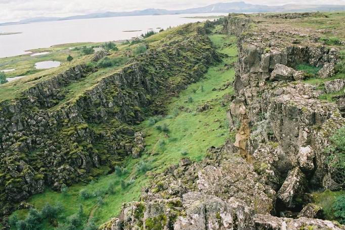
The Rift
In geology, a rift, or a disambiguation, is a linear zone where the lithosphere is being pulled apart.
The lithosphere includes the crust and the uppermost mantle, which constitute the hard and rigid outer layer of the earth. This layer of the Earth’s crust is about 60 miles thick, and consists of about 12 different layers, or tectonic plates. Radioactive heating of the interior and slow convection currents deep in the mantle are believed to be the cause of the few inches of movement per year of the tectonic plates.
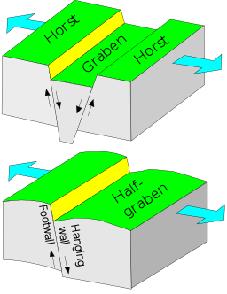
The image above shows a full-graben rift, where both sides of the rift are uplifted, leaving a depressed area between. (Image credit: Sansculotte at German language Wikipedia, used under creative commons.)
![]()
Typically rifts have a central linear downfaulted depression on one side, called a half-graben. A single tectonic plate segment often dominates, causing the rift to lift up on only one side. Volcano activity is part of many, but not all, rift formations. Rifts often form where two tectonic plates have a divergent boundary. Most rifts contain many segments controlled by a single basin-bounding fault.
Rift Formation
Initially, the upper layer of the lithosphere begins to extend along a series of faults that are not connected. This causes the formation of isolated basins. As the rift evolves, the faults eventually link together to form larger fault boundaries. Significant uplift of the rift shoulders begins next, and this influences sedimentation and water drainage in the rift basins. The crust is thinned, and the boundary between the earth’s crust and the mantle (called the Moho, named after a pioneering seismologist) becomes raised up. The Moho lies entirely within the lithosphere layer.
Once the process of rifting ends, the mantle underneath the rift cools and an area of subsidence, or gradual caving in or sinking of the land, remains. The size of the area of subsidence depends on how much thinning of the crust and how much sediment shifting happened in the process.
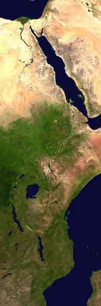
Above: Great Rift Valley. NASA satellite image in public domain.
There are different types of rifts that occur in varied processes. Rifts can occur in multiple phases and over 100 million years, such as the North Sea rift. Continental rifts can occur over a range of 60 to several hundred miles, and involve many faults, such as the East African rift. The Dead Sea is an active pull-apart basin rift (also called OTZs, or overlapping tension zones), formed when an area of subsidence allowed a lot of space for sediment deposition where there are two overlapping faults, causing the basin to sink down.
Please send CO (through profile or messaging) answers to the following questions. Short answers are fine.
1. Include a photo of the rift and yourself and/or your party with your log (optional).
2. Are both sides of this rift lifted up? According to your answer, is this a full-graben or half-graben rift?
3. What kind of rift creates the Dead Sea?
4. Estimate the height and length (as much of it as you can see from the GZ) of the rift in front of you.
5. How many rift formations can you see as you travel along this ¼ mile stretch of the highway at the GZ area of the two waypoints? Describe what type of rifts you see at these two waypoints, in short answers.
Sources: https://en.wikipedia.org/wiki/Rift, https://www.britannica.com/science/lithosphere, https://en.wikipedia.org/wiki/Mohorovi%C4%8Di%C4%87_discontinuity, wikimedia